
-
Mail us:
editor@raftpubs.org
- ISSN : xxxx-xxxx
Indexing & Abstracting
Full Text
Research ArticleDOI Number : 10.36811/ijpsh.2021.110030Article Views : 91Article Downloads : 61
Assessment of Sediment and Nutrient Losses from Forest, Pasture, Tea and Cropped Farms along the Nyondo River Basin
Omolo Paul Ochieng1*, Andrew Nderitu1, Harun Odhiambo2 and David M. Kamau1
1Kenya Agricultural and Livestock Research Organization (KALRO), P.O. Box 1490 Kisumu, Kenya
2Kenya Agricultural & Livestock Research Organization: Food Crop Research Center - Muguga South
*Corresponding Author: Omolo Paul Ochieng, Kenya Agricultural and Livestock Research Organization (KALRO), P.O. Box 1490 Kisumu, Tel: +254 722 656 483; Email: ochiengomolo@gmail.com
Article Information
Aritcle Type: Research Article
Citation: Omolo Paul Ochieng, Andrew Nderitu, Harun Odhiambo, et al. 2021. Assessment of Sediment and Nutrient Losses from Forest, Pasture, Tea and Cropped Farms along the Nyondo River Basin. Int J Plant Sci Hor. 3: 45-52.
Copyright: This is an open-access article distributed under the terms of the Creative Commons Attribution License, which permits unrestricted use, distribution, and reproduction in any medium, provided the original author and source are credited. Copyright © 2021; Omolo Paul Ochieng
Publication history:
Received date: 07 June, 2021Accepted date: 11 June, 2021
Published date: 14 June, 2021
Abstract
The widespread poor agricultural practices and ancient technologies continuously aggravate erosion of sediments and soil nutrients from delicate terrains at the major catchments of water shades. The ongoing study is assessing soil and nutrient losses in the four major land use covers (forest, pasture, tea and maize farms) in the upper catchment of Nyondo River Basin. The study sites in the upper catchment of Nyondo River Basin are densely populated and receive bimodal rains that support agriculture which is the main economic activity supporting livelihoods of the communities in the region. The experiment is laid in a randomized complete block design (RCBD) with each of the land use covers replicated 3 times with erosion traps mounted on 150 m2 plots. First data set was collected during the short rainy season of 2019 and long rainy season of 2020, with subsequent data collection continuing up to the short rainy season of 2021. Preliminary results showed that soil and nutrients were significantly lost in maize fields (p=0.05), forest cover was the least vulnerable while pasture cover had the highest surface runoff. Nutrient concentrations in the eroded sediments (p=0.05) were significantly higher than those that remained in maize plot while forest and tea fields registered comparable effectiveness in reducing both soil and nutrient losses, seasons notwithstanding. Pasture and maize fields had the highest water loss due to low infiltration rate and were also vulnerable to sediment and nutrients loss through surface runoff. The information will be used to inform and advise stake holders on land use policies geared towards attainment of sustainable agriculture and water quality in Nyondo and areas with similar landscapes and agricultural practices.
Keywords: Erosion; Sediment; Nutrients; Land use
Introduction
Soil erosion is a phenomenon that is experienced worldwide and directly impacts on agricultural productivity. It is particularly highest in the ago ecosystems of Asia, Africa and South America. In these regions, soil losses are estimated at 30-40 t ha-1 yr-1 [1]. The situation is more severe in developing countries on small scale farms located on marginal areas and steep terrains. Soil erosion destroys soil structure, reduces organic matter content within the top layer and causes siltation along river banks thus diminishing the productivity in natural ecosystems, agricultural, forest, and rangelands [2]. According to [3] a net result of land degradation may culminate in a vicious circle of low income, low input and low yield. Improper land management practices are thus a serious threat to the expansion of agricultural landscape and a major drawback to achievement of high yields, and conservation of biodiversity, especially in the advent of climate change. The net effects of these challenges are food insecurity and rise in poverty levels among the smallholder farmers who form the majority of rural population in Africa. Consistent massive annual loss of sediments and nutrients from catchments triggers poor soil quality which lowers crop yields and causes ecological imbalances as well as degradation of the environment [1,2]. Both Mara River Basin and Nyondo River Basin have similar futures. The Mara River Basin in East Africa is a transboundary basin of international significance experiencing excessive levels of sediment loads. Sediment levels in this river are extremely high (turbidities as high as 6,000 NTU) and appear to be increasing over time. The rise in human and wildlife populations, unregulated livestock grazing, and agricultural land conversion by destruction of natural vegetation covers such as forests are among the potential factors increasing sediment loads in the semi-arid portion of the basin. Nyondo River Basin forms a major catchment of Lake Victoria Basin. The basin lies between 1800 and 3000 m above sea level and covers an area of 3550 km2 with a population of about 500,000 [4]. The highland is dominated by major and minor escarpments, hills, volcanic foot ridges, foot slopes, uplands, plateau and erosion vulnerable plains. There is overexploitation of available resources by the ever-increasing population in the basin. The situation is further aggravated by widespread application of improper land-use practices in the vulnerable areas. Such improper practices result in loss of top soils and nutrients [3,5,6]. Quite a number of eroded paths and fields in Nyondo Basin are deepening and widening in size. Formation of huge gulley, siltation at the river mouths and high eutrophication level in Lake Victoria are clear evidences of the environmental degradation taking place in the basin [7]. The study aimed at determining the extent of losses of sediment, nutrient and surface runoff emanating from major land use covers in the upper part of Nyondo Basin.
Research Methodology
Study Area
The study was conducted in Tendered highlands in Nyondo basin (Figure 1). The area forms part of highly dissected piles of Laval deposits and an extension of Kenya highland from South East corner of the country [8]. Though agriculturally active, the area has a rugged landscape which is highly vulnerable to land degradation. The steep gradient of the terrain makes the area one with the highest levels of erosion in the basin. Evidence of severe erosion is overwhelming. Indeed, studies have identified the region as one of the top erosion hot spots in Lake Victoria basin [9] Majority of the land is covered by forests (exotic and indigenous), pasture, tea and food crops such as maize.
Experimental set up
Sediment, nutrient and surface runoff losses associated with four major agricultural land use covers (forest, pasture, tea and maize farms) in Tendered Sub County were monitored for two cropping seasons using silt traps that were laid in a randomized complete block design (RCBD) arrangement with each of the land use cover replicated 3 times (Figure 2). Plots measuring 15 x 10 m were delineated in selected existing fields using pieces of galvanized (G 26) plain sheets as guards, each measuring 2 m (length) x 35 cm (width). The purpose of delineation was to use a limited portion of the farmers land with specific land cover with an aim of trapping rain water that is directed into a series of drums and pipes to avoid run-off mixing from which the soil and water samples are collected on regular basis. The guards were lined in furrows, with 8 cm overlaps at each end around the plots. The guard sheets were concreted in the furrows and water cured to remain in position. The overlapping ends of running strips of the guards were riveted to stop inflow and or outflow of runoffs into or from erosion plots except through the conveyor channel. Pipes measuring 30 cm in diameter were fitted to drain the runoff to the first divider tank and further conveyed to a second tank from which runoff and sediments were captured, collected and labelled accordingly prior to submitting the same for laboratory analysis. Rainfall readings were recorded over the period of experimentation. Soil samples (0-30 cm) were collected at the onset of the experiment and at the end of the two-consecutive season. The samples were analyzed for nutrient concentrations according to the procedures described by [10]. Seasonal data on soil, nutrient and surface runoff losses associated with targeted land use covers were collected and subjected to statistical analysis using SAS Statistical package.
Results
Precipitation at experimental site
Results presented in Figure 3 show rainfall received from the month of September to December 2019 and March to August 2020. The seasons marked short and long rains, respectively had not only similar distribution within the season but also received insignificant difference (p > 0.05) in intensity. The short rains season recorded 1009.1 mm while long rains season received 1010.4 mm during the period of crop (maize) growth. Most rains were recorded in the months of October and November during the short season while long rains were registered mainly in the months of April and May. September and August had the least rains recorded in short and long rainy seasons, respectively.
Soil loss
There was a variation in soil loss across land use covers as evidently shown in Figure 4. Of the four-land use covers, maize field registered a significantly (p = 0.04) high soil loss (108 t ha -1) compared to pasture (30.8 t ha -1), tea (7.9 t ha -1) and forest (6.6 t ha -1). Pasture field was the second most vulnerable land use cover. The losses recorded from either tea or forest covers were about 25% of what was obtained from pasture land. The total soil lost through surface runoff from pasture was also about 25% of the total soil lost in the maize field. Both tea and forest cover had comparable soil losses.
Surface runoff
The quantity of runoffs captured varied with land use covers. Seasonal variations were also obtained across land covers except in tea field (Figure 5). There was a significantly high (p = 0.04) total surface runoff loss from pasture (405 m3 ha -1) field compared to the loss associated with the other three land use covers during 2015 short rains. Maize field recorded second highest loss (247 m3 ha -1) during the same season while forest and tea field registered comparable (181 and 201 m3 ha -1) losses, respectively. Pasture and maize land use types had total surface runoff losses of 857 and 708 m3 ha -1 respectively. Tea and forest cover recorded comparable losses which were about half of what was lost from pasture land.
Nutrient concentrations in eroded sediments
Forest and tea fields lost significantly (p = 0.05) high O.M followed by pasture and maize covers respectively (Table III).
Nutrient losses in runoff
Results presented in Table IV highlights nutrient concentrations that were captured in the surface runoff samples from different land use covers. Surface runoff from tea farm had significantly (p =0.046) high nitrate concentration compared to other land use types studied.
Discussion
The variations in soil loss across land use covers were a reflection of the intensity of ground and canopy cover of the four-land use covers in this study. The highest soil loss (118 t ha -1) obtained from maize plot was attributed to the fact that the ground surface was still loose as land had been ploughed for planting in the month of February, just before the onset of long rains in March 2016. Maize is a short season crop and farmers involved in its production practice regular ploughing after every 3 to 4 months. This operation loosens soil structure thus exposing surface soil to degradation by erosion. In addition, the morphology of maize foliage and it’s recommended spacing makes the crop a relatively poor ground cover. Both tea and forest land covers registered less losses due to relatively better canopy and ground cover compared to the situations that were in either pasture or maize fields. Forest trees and tea as a crop are permanent vegetative covers. This implies minimal disturbance of the soil structure of tea and forest lands by human activity. Besides, the root systems of these vegetation are elaborate thus holding the soil particles together to reduce loss of top soil by surface runoff. The relatively high soil losses observed under pasture plot was attributed to the fact that the grass that covered surface ground had been browsed on and drastically reduced to the ground level. The prolonged dry weather that was experienced 3 months to the onset of rains in March 2020 is likely to have worsened the situation thereby exposing the field and letting it become vulnerable to erosion [6] hence the observed trend. Erosion is a function of local factors that include canopy cover, topography, ground cover, soil property and intensity of precipitation. Thus, variations in losses of surface runoffs observed across agricultural land use types, was not surprising. Studies carried out have demonstrated that the more the ground and canopy cover is on the surface, the less the surface runoff, other factors held constant. For instance, in a study that compared losses of rainfall water through surface runoff in different agricultural land use types, [11] reported that banana and coffee fields lost relatively less water compared to degraded range land. The high losses of water observed in the pasture field were more during long rains compared to short rains, a trend which was attributed to the prolonged dry spell in the preceding months to the onset of rains that consequently accelerated over grazing on the insufficient pasture lands by large herds. Results presented in Table III showed that there was relatively high nutrient concentration in the eroded sediments compared to the remaining soil in the experimental plots. The results further reveal a varied trend in nutrient losses under different land use practices, seasons notwithstanding. The significant loss of nitrogen and phosphorus from both tea and maize fields was expected as these fields had in the immediate past season received inorganic fertilizers (DAP and NPK) at varying rates. On the other hand, our findings partly agree with those of [12] who reported significantly high levels of nutrients nitrate-nitrogen and phosphate phosphorus in the discharges from tea farms. Losses of P, Ca and Mg through surface runoff were not dependent of land covers. This observation suggest that the significantly different nutrient losses associated with different land types reported in the Table I,II above are carried in eroded sediments. Thus, losses through surface runoffs [11] formed a small fraction of the total nutrient lost through erosion in any of the land use covers studied [13].
|
Table I: Initial chemical properties of top soil of land use covers studied. |
||||||
|
|
Land use |
|
OM% |
N % |
P mg/kg |
Kmg/kg |
|
PH |
||||||
|
|
|
5.5 |
1.15 |
0.11 |
184 |
7.8 |
|
maize |
||||||
|
|
forest |
5.3 |
6.13 |
0.49 |
313.5 |
25.2 |
|
|
tea |
5 |
5.86 |
0.37 |
512.42 |
11.38 |
|
|
pasture |
5.4 |
1.97 |
0.14 |
208.28 |
3.64 |
|
Table II: Chemical properties of soils of land use covers after two cropping seasons. |
|||||
|
Land cover |
PH |
OM% |
N% |
P mg/kg |
Kmg/kg |
|
maize |
5.4 |
1.17 |
0.15 |
142 |
6.3 |
|
forest |
5.5 |
6.42 |
0.16 |
247 |
30.2 |
|
tea |
5 |
6.09 |
0.31 |
505 |
22.6 |
|
pasture |
5.3 |
1.6 |
0.14 |
84 |
5.1 |
|
Lsd (0.05) |
NS |
2.48 |
0.09 |
294 |
12.33 |
|
Table III: Nutrient concentration of eroded sediments from major land use covers in upper Nyondo Basin. |
|||||
|
|
Land use |
OM (%) |
N (%) |
P (mg/kg) |
Kmg/kg) |
|
Short rains 2019 |
Maize |
4.84 |
0.23 |
271 |
|
|
|
pasture |
3.05 |
0.13 |
128 |
19.5 |
|
|
Forest |
9.32 |
0.39 |
105 |
54.9 |
|
|
Tea |
7.89 |
0.49 |
479 |
15.4 |
|
Long rains 2020 |
Maize |
3.58 |
0.28 |
384 |
31.2 |
|
|
pasture |
2.35 |
0.16 |
257 |
20.8 |
|
|
Forest |
10.33 |
0.38 |
301 |
49.6 |
|
|
Tea |
7.1 |
0.47 |
526 |
34.7 |
|
LSD (0.05) |
Between seasons |
4.25 |
NS |
NS |
NS |
|
|
Across land use |
1.37 |
0.09 |
98 |
11.2 |
|
Table IV: Means of nutrient concentration lost in runoffs from major land use covers. |
|||||
|
Land use cover |
Nitrate (mg/l) |
Nitrite (mg/l |
Total P (mg/l) |
Ca (mg/l) |
Mg (mg/l) |
|
Maize |
0.054 |
0.031 |
0.424 |
6.96 |
1.322 |
|
Pasture |
0.028 |
0.004 |
0.372 |
8.157 |
2.238 |
|
Forest |
0.038 |
0.01 |
0.437 |
6.638 |
1.856 |
|
Tea |
0.24 |
0.022 |
0.339 |
5.833 |
1.337 |
|
Lsd (0.05) |
0.021 |
Ns |
ns |
ns |
ns |
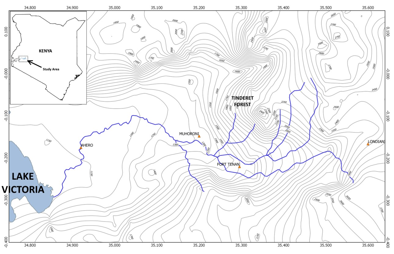
Figure 1: Elevation profile of Nyondo River Basin, Kenya.
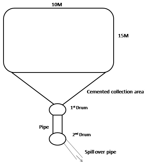
Figure 2: Silt trap illustration for collection of run-off and sediments.

Figure 3: Monthly rainfall during experimentation in upper Nyondo Basin.
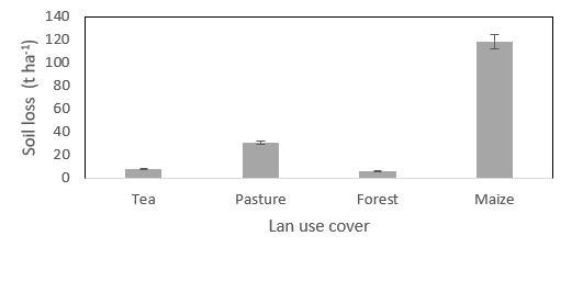
Figure 4: Soil loss from major land covers in Upper Nyondo Basin.
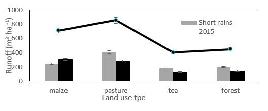
Figure 5: Surface runoff from major land use covers in upper Nyondo Basin.
Conclusion
Results generated by this study points out that pasture and maize fields are the most vulnerable land covers in terms of waste of rainfall water, sediment and nutrients through surface runoff. In addition, maize field toped in loss of soil due to the fact that the ground surface is regularly disturbed in preparation of fresh planting.
<pRecommendation>
In order to reduce in environmental degradation of such fields, the control of wildlife populations, regulated livestock grazing, and agricultural land conversion practices are recommended. Along term study to regularly monitor the trends of degradation and deliberate efforts to sensitize and capacity build the communities to adopt conservation measure and practices on their farms is strongly recommended. Further research is needed to determine the percentage of supplemental soilbased plant nutrients lost to surface runoff and it impact on the total biomass yield of tea and maize.
Acknowledgement
The authors wish to expressly thank World Bank for financial support through the Kenya Climate Smart Agriculture Project (KCSAP). The authors equally extend their appreciation to the staff in the State Department of Agriculture- Tendered Sub County for their support and to farmers, who voluntarily donated their fields, for this research work.
References
1. Taddese G. 2001. Land degradation. A challenge to Ethopia. Environment Management. 27: 815-826. Ref.: https://pubmed.ncbi.nlm.nih.gov/11393316/ Doi: https://doi.org/10.1007/s002670010190
2. Pimentel D. 2001. The limitation of biomass energy. in Encyclopia of Physical Science and Technology, San Diego, Academic Press. 159-171.
3. Garcia-Ruiz R, Pattinson SN, Whitton BA. 1998. Denitrification in River Sediments: Relationship Between Process Rate and Properties of Water and Sediment. Freshwater Biology GTZ report. Causes of soil degradation and development approaches to sustainable soil management. Magraf Verlag, Weikersheim. Germany. 39:467-476.
4. Mungai D, Swallow B, Mburu J, et al. 2004. Proceedings of a Workshop on Reversing Environmental and Agricultural Decline in the Nyando River Basin. December. 2002, Imperial Hotel, Kisumu, Kenya. 9-11.
5. Moreau S, Bertru G, Buson C. 1998. Seasonal and Spatial Trends in Nitrogen and Phosphorus Loads to the Upper Catchment of the River Valaine (Brittany): Relationships with Land Use. Hydrobiologia. 374: 247-258.
6. Okalebo JR, Othieno CO, Maritin HK, et al. 2005. Management of Soil fertility in W. Kenya: Experience working with smallholder farmers. Africa Crop Sci. Proc. 7: 1465-1473.
7. Magunda MK, Tenywa MM. 2001. Soil and water conservation. In: Agriculture in Uganda. 1: 145-168.
8. Nandi County Development Plan (2013-2017). Effective management for sustainable economic growth and poverty reduction. Ministry of finance and planning. Government Printers, Nairobi. 111.
9. Walsh M, Shepherd K, Verchot L. 2004. Identification of sediment sources and sinks in the Nyando river basin. In D. Mungai, B. Swallow, J. Mburu, L. Onyango and A. Njui (eds.), Proceedings of a Workshop on Reversing Environmental and Agricultural Decline in the Nyando River Basin, ICRAF: Nairobi, Kenya. 27-32.
10. Okalebo JR, Gathua KW, Woomer PL. 2002. Laboratory methods in soil and plant analysis: A working manual. Second edition. TSBF-CIAT and SACRED Africa, Nairobi, Kenya. 116.
11. Magunda MK, Majaliwa JGM, Tenywa MM. et al. 2003. Runoff, Soil and Nutrient Losses from Major Agricultural Land-use Practices in the Lake Victoria Basin, Uganda. Afri. J. Hydrobiol. Fish. 87-102.
12. Raburu PO, Okeyo-Owuo JB. 2002. Impact of agro-industrial activities on the water quality of River Nyando, Lake Victoria Basin, Kenya. 80.
13. Jaetzold R, Schmidt H, Hornetz B, et al. 2009. Farm Management Handbook of Kenya Vol. ii. Natural Conditions and Farm Management Information. 2nd Edition. Part A. West Kenya.